Africa Maps
World Atlas >

 Africa is the 2nd largest continent on Earth, following Asia in size.
Africa measures 11,730,000 square miles (30,370,000 square kilometers).
It comprises 20.4% of the land area on Earth and 6% of the Earth's surface.
Africa is the 2nd largest continent on Earth, following Asia in size.
Africa measures 11,730,000 square miles (30,370,000 square kilometers).
It comprises 20.4% of the land area on Earth and 6% of the Earth's surface.
Africa consists of 54 countries, some of which are among the poorest in the world. The Sudan is the largest country in Africa, and Seychelles is the smallest.
Africa is divided into several regions which are marked by striking climate variations. The continent features highlands on both the East and West coasts and plains in the middle. Africa has two deserts — the Sahara and the Kalahari. The Sahara is the largest desert on Earth; it covers 3,500,000 sq. mi. (9,065,000 sq. km.) and is always growing. The desert ranges in elevation from 100 ft. below sea level, to more than 11,000 ft. (3,350 m.). In contrast, the Kalahari Desert is about 100,000 sq. mi. (259,000 sq. km.) and covers most of Botswana, part of South Africa, and western Namibia.
 On the edge of the Sahara is the Sahel, an area of land that sits between
desert and tropical areas and receives as little as 6 to 8 inches of
precipitation per year. It is an area of transition on which the
expanding Sahara Desert is constantly encroaching.
On the edge of the Sahara is the Sahel, an area of land that sits between
desert and tropical areas and receives as little as 6 to 8 inches of
precipitation per year. It is an area of transition on which the
expanding Sahara Desert is constantly encroaching.
Africa is also home to a rainforest, lying within the Congo River Basin. This fertile basin covers the Democratic Republic of the Congo and much of the Congo; reaching also into Angola, Cameroon, the Central African Republic, and Zambia. It occupies about 1,400,000 sq. mi. (3,600,000 sq. km.) and contains nearly 20% of the world's rain forest.
Africa features several mountain ranges. There are the Atlas Mountains along the Mediterranean coastline in the northwest, and a number of large mountains line the Great Rift Valley in the east. This valley is a low lying area that extends from the Red Sea to Mozambique. Along the edge of the Great Rift Valley sits Mount Kilimanjaro which has two peaks (Kibo and Mawenzi). Kibo is the highest point on the continent and stands at 19,321 feet (5889 meters).
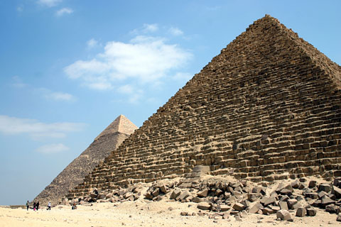
Africa is known for its unique land formations as well as its ancient man-made structures. African travel destinations include Victoria Falls on the Zimbabwe and Zambia border, the Nile River, which is the longest river in the world, and the ancient Sphinx and pyramids. The Great Pyramid of Giza in Egypt was the tallest man-made structure until the Eiffel Tower was constructed in 1889.
Africa Map
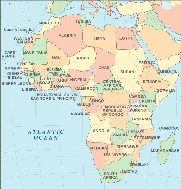
Interactive Africa Map
African Countries
The table below lists the countries of Africa and their capital cities, and also features convenient links to maps and detailed information about each African country.
| African Countries And Capitals | |
|---|---|
| Country Name | Capital City |
| Algeria | Algiers |
| Angola | Luanda |
| Benin | Porto-Novo |
| Botswana | Gaborone |
| Burkina Faso | Ouagadougou |
| Burundi | Bujumbura |
| Cameroon | Yaounde |
| Cape Verde | Praia |
| Central African Republic | Bangui |
| Chad | Ndjamena |
| Comoros | Moroni |
| Congo Democratic Republic | Kinshasa |
| Congo Republic | Brazzaville |
| Djibouti | Djibouti |
| Egypt | Cairo |
| Equatorial Guinea | Malabo |
| Eritrea | Asmara |
| Ethiopia | Addis Ababa |
| Gabon | Libreville |
| Gambia | Banjul |
| Ghana | Accra |
| Guinea | Conakry |
| Guinea-Bissau | Bissau |
| Ivory Coast | Yamoussoukro |
| Kenya | Nairobi |
| Lesotho | Maseru |
| Liberia | Monrovia |
| Libya | Tripoli |
| Madagascar | Antananarivo |
| Malawi | Lilongwe |
| Mali | Bamako |
| Mauritania | Nouakchott |
| Mauritius | Port Louis |
| Morocco | Rabat |
| Mozambique | Maputo |
| Namibia | Windhoek |
| Niger | Niamey |
| Nigeria | Abuja |
| Rwanda | Kigali |
| Sao Tome and Principe | Sao Tome |
| Senegal | Dakar |
| Seychelles | Victoria |
| Sierra Leone | Freetown |
| Somalia | Mogadishu |
| South Africa | Pretoria |
| South Sudan | Juba |
| Sudan | Khartoum |
| Swaziland | Mbabane |
| Tanzania | Dodoma |
| Togo | Lome |
| Tunisia | Tunis |
| Uganda | Kampala |
| Zambia | Lusaka |
| Zimbabwe | Harare |
See the CIA World Factbook home page for information about this helpful geopolitical resource, and visit this map of Africa website for more Africa maps and African travel information.
Detailed Country Maps
World-Atlas.us is a Chosen Sites™ reference source.
To facilitate browsing, certain links will open in new windows.