
Europe Maps
World Atlas >

 Europe ranks sixth in land size. Only the continent of Australia is
smaller. Europe covers 4,010,000 square miles (10,400,000 square
kilometers) and takes up 2% of the Earth's surface.
Europe ranks sixth in land size. Only the continent of Australia is
smaller. Europe covers 4,010,000 square miles (10,400,000 square
kilometers) and takes up 2% of the Earth's surface.
Europe is bounded by the Arctic Ocean to the North, the Atlantic Ocean to the West, the Mediterranean Sea to the South and the Ural Mountains and Caspian Sea to the East. It comprises 43 countries.
The topography of Europe varies greatly despite being limited to a small area. There are several mountain ranges, including the Alps, the Balkans, the Urals, the Pyrenees, and several smaller ranges.
 The Alps run along south-central Europe for almost 700 miles. The Balkan
Mountains, which cover much of the Balkan Peninsula, are home to Mt. Olympus,
the highest peak in Greece. This mountain is a major part of Greek
mythology and was once considered the home of the gods.
The Alps run along south-central Europe for almost 700 miles. The Balkan
Mountains, which cover much of the Balkan Peninsula, are home to Mt. Olympus,
the highest peak in Greece. This mountain is a major part of Greek
mythology and was once considered the home of the gods.
The Urals form a border between Asia and Europe and run 1,640 miles (2,640 kilometers). The Pyrenees also form a natural border. They run between France and Spain and extend over 250 miles from the Bay of Biscay to the Mediterranean Sea.
The highest point in all of Europe is not located in any of these well known mountain ranges. Mt. Elbrus, which stands at 18,481 feet (5,633 meters), is part of the volcanic Caucasus Mountains. This range stretches from the Caspian to the Black Sea.
Europe has several well-known rivers. There is the Danube that starts in Germany and forms the border between Romania and Bulgaria before emptying into the Black Sea. The Po, Italy's longest river, flows west to east through northern Italy and empties into the Adriatic Sea. The Rhine and the Rhone both originate in Switzerland and run through the surrounding countries of Germany and France. The Thames river runs straight through London before emptying in the North Sea.
Europe is home to a number of plateaus, highlands, and plains. Most notable is the North European Plain. This fertile land area runs in a crescent shape from the Alps to the Baltic Sea, from whence it continues into the Scandinavian countries and Russia.
Another area of interest is the Scandinavian Shield. This extremely rocky area was ground down by passing glaciers thousands of years ago. The area is now home to thousands of small lakes and rivers.
Europe is known for its stunning architecture and unique cultures that vary from country to country. Cities like Paris, London, and Florence, among many others, draw tourists year after year.
Europe Map
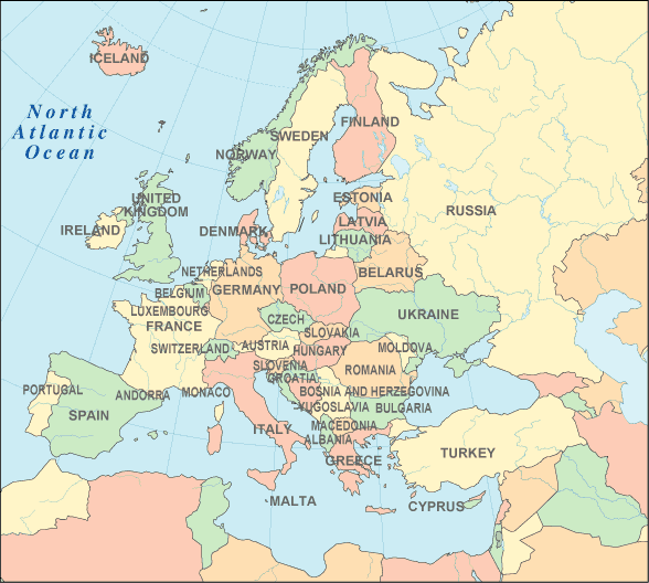
Interactive Europe Map
European Countries
The table below lists the countries of Europe and their capital cities, and also features convenient links to maps and detailed information about each European country.
| European Countries And Capitals | |
|---|---|
| Country Name | Capital City |
| Albania | Tirana |
| Andorra | Andorra la Vella |
| Austria | Vienna |
| Belarus | Minsk |
| Belgium | Brussels |
| Bosnia and Herzegovina | Sarajevo |
| Bulgaria | Sofia |
| Croatia | Zagreb |
| Cyprus | Nicosia |
| Czech Republic | Prague |
| Denmark | Copenhagen |
| Estonia | Tallinn |
| Finland | Helsinki |
| France | Paris |
| Germany | Berlin |
| Greece | Athens |
| Hungary | Budapest |
| Iceland | Reykjavik |
| Ireland | Dublin |
| Italy | Rome |
| Latvia | Riga |
| Liechtenstein | Vaduz |
| Lithuania | Vilnius |
| Luxembourg | Luxembourg |
| Macedonia | Skopje |
| Malta | Valletta |
| Moldova | Chisinau |
| Monaco | Monaco |
| Montenegro | Podgorica |
| Netherlands | Amsterdam |
| Norway | Oslo |
| Poland | Warsaw |
| Portugal | Lisbon |
| Romania | Bucharest |
| San Marino | San Marino |
| Serbia | Belgrade |
| Slovakia | Bratislava |
| Slovenia | Ljubljana |
| Spain | Madrid |
| Sweden | Stockholm |
| Switzerland | Bern |
| Ukraine | Kiev |
| United Kingdom | London |
| Vatican City | Vatican City |
See the CIA World Factbook home page for information about this helpful geopolitical resource, and visit this map of Europe website for more Europe maps and European travel information.
Detailed Country Maps
- Map of France
- Map of Germany
- Map of Greece
- Map of Ireland
- Map of Italy
- Map of Russia (located in both Europe and Asia)
- Map of United Kingdom
World-Atlas.us is a Chosen Sites™ reference source.
To facilitate browsing, certain links will open in new windows.