
North America Maps
World Atlas >

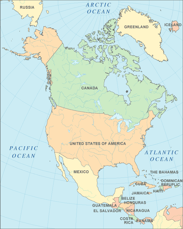
North America
| South America
 North America is the 3rd largest continent on Earth, covering approximately
9,450,000 square miles (24,490,000 square kilometers). It makes up 4.8%
of the Earth's surface and consists of 23 countries.
North America is the 3rd largest continent on Earth, covering approximately
9,450,000 square miles (24,490,000 square kilometers). It makes up 4.8%
of the Earth's surface and consists of 23 countries.
North America touches three oceans — the Atlantic to the East, the Pacific to the West and the Arctic to the North. North America and South America are connected by the Isthmus of Panama.
Like South America, North America is named for Amerigo Vaspucci, an Italian cartographer who was the first to suggest that the Americas were a new land rather than being part of the East Indies.
North America features several gulfs. The Gulf of Mexico is the largest such gulf, followed by Hudson Bay, the Gulf of St. Lawrence, and the Gulf of California. It is also home to several large rivers. The Mississippi drains midwestern United States and empties into the Gulf of Mexico. The Colorado runs through southwestern U.S. and empties into the Gulf of California. The Columbia drains the Pacific Northwest, emptying into the Pacific Ocean. The Mackenzie flows through the Canadian northwest and empties into the Arctic Ocean.
 The Great Lakes, a grouping of five of the largest freshwater lakes, also lie
within North America. When combined with the St. Lawrence River, they
become the largest freshwater system in the world. They are located near
the U.S. and Canada border and surround the state of Michigan.
The Great Lakes, a grouping of five of the largest freshwater lakes, also lie
within North America. When combined with the St. Lawrence River, they
become the largest freshwater system in the world. They are located near
the U.S. and Canada border and surround the state of Michigan.
In the west, the Rocky Mountains cover over 2,000 miles, extending from Mexico up to Canada and eastern Alaska. Also in the western portion of the continent is Mt. McKinley, the highest point in North America, reaching 20,320 ft. (6,194 m.). It is situated in the Alaska Mountain Range that covers much of south-central Alaska and continues into Canada's Yukon Territory.
The Appalachians in the east run about 1,500 miles and extend from Alabama in the southern U.S. to the Canadian province of Newfoundland.
Parts of the continent's coastline are dotted with bayous, deltas, marshes, mud flats and swamps.
The fertile Great Plains of North America are known as the heartland of the continent and are covered with farms. The land is generally smooth and treeless with sloping shallow river valleys.
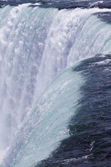
Visitors flock to the sunny beaches on the coasts of North America, to large cities like Toronto and Las Vegas, and to unique sites like the Niagara Falls and the Grand Canyon.
North America Map
Interactive North America Map
Interactive Western North America Map Inset
North American Countries
The table below lists the countries of North America and their capital cities, and also features convenient links to maps and detailed information about each North American country. For a detailed map and information about North America's Caribbean Sea region, please visit Caribbean Map.
| North American Countries And Capitals | |
|---|---|
| Country Name | Capital City |
| Antigua and Barbuda | Saint John's |
| Bahamas | Nassau |
| Barbados | Bridgetown |
| Belize | Belmopan |
| Canada | Ottawa |
| Costa Rica | San Jose |
| Cuba | Havana |
| Dominica | Roseau |
| Dominican Republic | Santo Domingo |
| El Salvador | San Salvador |
| Grenada | Saint George's |
| Guatemala | Guatemala City |
| Haiti | Port-au-Prince |
| Honduras | Tegucigalpa |
| Jamaica | Kingston |
| Mexico | Mexico City |
| Nicaragua | Managua |
| Panama | Panama City |
| Saint Kitts and Nevis | Basseterre |
| Saint Lucia | Castries |
| Saint Vincent and the Grenadines | Kingstown |
| Trinidad and Tobago | Port-of-Spain |
| United States of America | Washington D.C. |
See the CIA World Factbook home page for information about this helpful geopolitical resource, and visit this map of North America website for more North America maps and North American travel information.
Detailed Country Maps
World-Atlas.us is a Chosen Sites™ reference source.
To facilitate browsing, certain links will open in new windows.